Times-Chronicle
Negotiations on the long-debated national park reserve in the South Okanagan are continuing through the pandemic between the province, the federal government and local Indigenous communities according to Parks Canada, who provided an update Wednesday — but no timeline as to when the national park would be established.
The last major step towards the national park was the signing of a memorandum of understanding (MOU) at the Osoyoos Desert Centre on July 2, 2019.
The agreement was signed by the Government of Canada, the Government of B.C., and the Syilx/Okanagan Nation as represented by the Osoyoos Indian Band (OIB) and the Lower Similkameen Indian Band to formally work toward establishing a national park reserve in the South Okanagan-Similkameen.
Both local Indigenous communities continue to engage on the proposal with their community members, according to Parks Canada.
“As the situation around COVID-19 evolves, work on the proposed national park reserve continues through the use of remote/virtual meeting technology. Even under normal circumstances, this is a detailed process that takes time, and seeks to address the concerns, needs, and priorities of each government and the communities they represent. There are many characteristics and considerations unique to the South Okanagan-Similkameen region. There is no specific timeframe for moving through the process; we need to take the time to do it right,” reads the statement from Parks Canada, attributed to the protected areas establishment team.
The presented “working boundary,” as of Aug. 12 identifies borders and areas of provincially-owned parklands and Crown lands that may one day be included in a national park reserve, following the negotiation of an establishment agreement. However, the boundary is “subject to further refinement as part of negotiation of the establishment agreement,” states Parks Canada.
“This working boundary does not affect private lands. Private land owners would not be subject to the Canada National Parks Act, associated regulations or policy. Private lands within the working boundary would only be acquired for inclusion in the national park reserve if there was both a willing-seller and a willing-buyer,” reads the statement from Parks Canada.
Since the signing of the MOU, Parks Canada and the B.C. Government have continued to meet with area directors of the Regional District of Okanagan-Similkameen (RDOS) in areas that overlap with the proposed national park reserve.
“Meetings between the RDOS, provincial ministries and Parks Canada will provide opportunities to review the negotiations topics and obtain feedback and input on matters important to constituents in the South Okanagan-Similkameen with regards to the proposed national park reserve. Similar meetings will occur with local governments from Keremeos, Osoyoos, Oliver and Penticton,” Parks Canada stated.
Regular updates, frequently asked questions, and a copy of the memorandum of understanding can be found on the Parks Canada website or the Let’s Talk South Okanagan website.
Proposed working boundary for National Park reserve in the South Okanagan
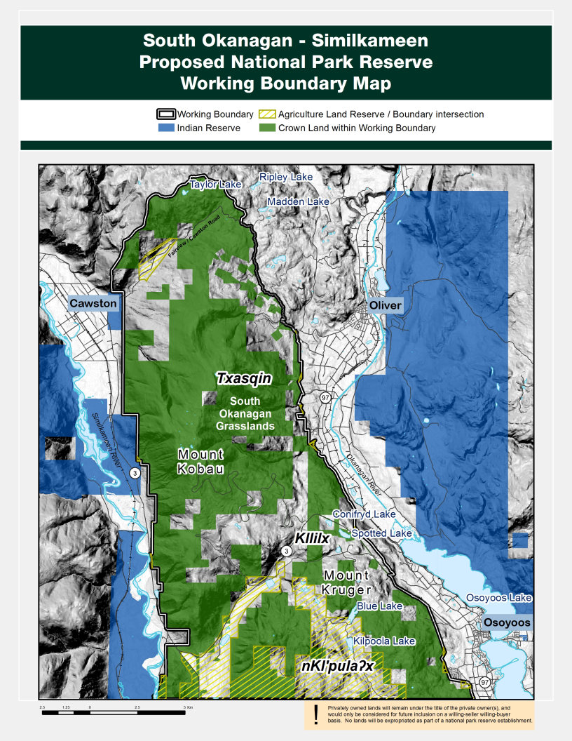
Source: Parks Canada
- The Western boundary lies roughly parallel to Highway 3 and the Similkameen River valley and trends at mid elevation from approximately 400 metres, Above Sea Level (ASL) to 520 metres (ASL).
- The Eastern boundary runs parallel to Highway 97 and the Okanagan River Valley and trends at mid elevation from approximately 450 metres (ASL) to 600 metres (ASL).
- The Southern boundary is the border between Canada and the United States and reaches an elevation of approximately 800 metres (ASL) at its highest point.
- The Northern boundary is the height of land (approximately 1,470 metres ASL) on Crown land to the north of the Fairview-Cawston Road.
- The boundaries protect the intact watershed catchment basin including the headwaters of the following creeks: Cawston, Conifryd, Reed, Hester, Testalinden, Tinhorn, Swartz, Togo, Lone Pine, Strawberry, and Blind.


