
By Don Urquhart, Times Chronicle
The movement of the Keremeos Creek wildfire has closed Hwy. 3A in both directions between Keremeos and Junction Hwy 97 (Kaleden Junction) for 31.5 km from about noon Tuesday, according to DriveBC. It’s not known when it might reopen.
The fire has moved downslope closer to Hwy 3A at the south end of Yellow Lake, and a control line is progressing along the highway, the BC Wildfire Service (BCWS) said in its Tuesday morning update. “This will limit growth and allow crews to safely access and establish containment lines.”
Yesterday evening (August 1) airtankers were able to do two passes with retardant but were unable to continue due to crosswinds, it said.
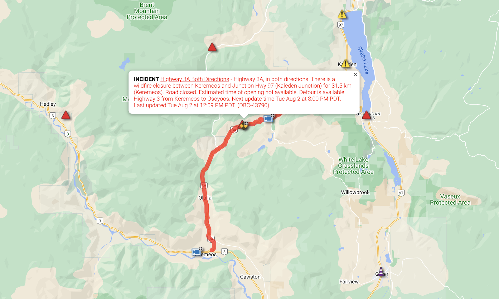
DriveBC map showing Hwy. 3A closure.
Crews are establishing control lines along the north side of Hwy 3A southwards to Green Mtn Road, as well as establishing a control line from Hwy 3A to top of Sheep Creek Road in preparation for ignitions operations. Planned ignitions are anticipated on the east flank in the next 24 hours.
Structure protection will be established where and as needed, the BCWS added.
Additional crews are establishing control lines from Green Mtn Rd working west and preparing Cedar Creek Road for potential burn operations by undertaking a complete danger tree assessment and falling along Green Mountain Road.
An Incident Management Team assumed management of the wildfire as of noon Sunday, July 31, 2022.
A total of 114 wildland firefighters are assigned to this fire working with an additional 115 structural protection personnel from fire departments across BC for a total crew complement of 229 firefighters. Eight helicopters and four pieces of heavy equipment are also working the fire.
The Keremeos Creek wildfire has grown to an estimated 2,790 hectares but its growth has been slowed by a temperature inversion over the last few days.
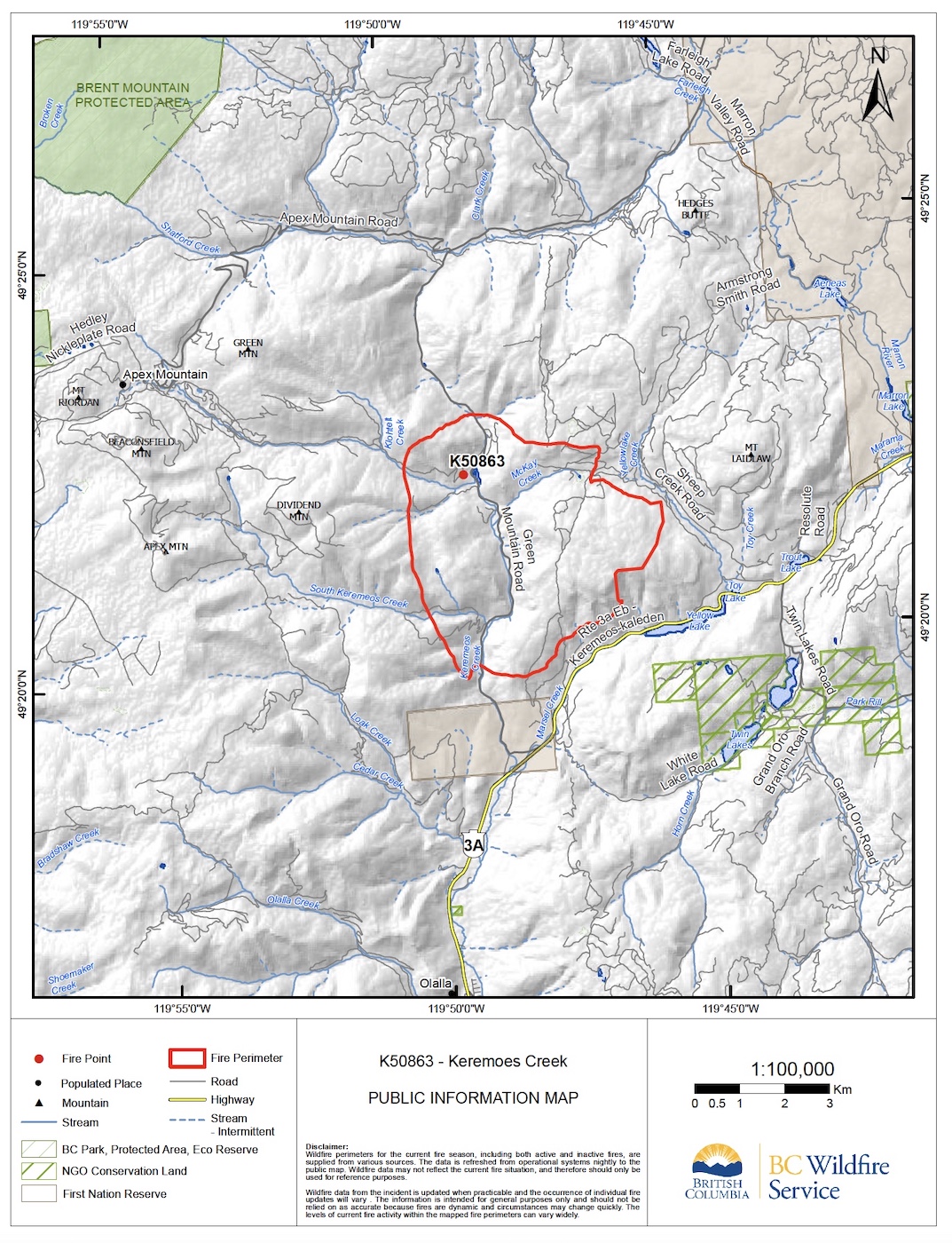
Updated perimeter map.
Speaking at a Regional District of Okanagan Similkameen (RDOS) briefing Monday afternoon, Bryan Zandberg, B.C. Wildfire Service (BCWS) information officer, said the previous two or three days have seen a temperature inversion which has slowed the pace of the fire.
He explained that a temperature inversion “is a band of air that is pushing smoke back down on the fire so less oxygen is available to it.”
He said the pattern in the last few days was an inversion in the morning and early afternoon breaking down when the temperature reaches 27-28°C which has seen the fire ramping up late afternoon and early evening. “We are anticipating the same situation today,” he added.
Wind gusts and the chance of thunderstorms are in the forecast for today (Monday), with Zandberg saying this scenario is “quite concerning.”
As of 2:30 p.m. Monday afternoon, 324 properties were under evacuation order and 73 properties were under evacuation alert. Most fall within Electoral Area I, with some in Area G as well. This includes the following areas: White Lake and Twin Lake communities; Hwy. 3A between Green Mountain Road and Olalla; Olalla, east of Hwy. 3A.
Much of the wildfire is located in terrain that is inoperable for air tanker and heavy machinery support, the BCWS said. But as the fire moves into an area to the west that is accessible to heavy equipment, it says it has begun building a line in Sheep Creek.
Zandberg noted that this fire has plenty of ‘well-cured’ fuel, low humidity level and localized weather conditions – like wind – which are pushing the fire in an “unorganized fashion.” “Overall it is not a very organized fire where we can predict the direction it is going,” he said
On the ranking of severity on a scale of 1-6, he said the fire was exhibiting Rank 4 behaviour but reached Rank 5 with some tree ‘candling.’
Fire growth is in steep and inaccessible terrain, the BCWS said. “Crews are building contingency lines, while continuing to concentrate their efforts on areas impacting residents; supporting structure protection.” Contingency line evaluation is being done in conjunction with First Nations and external partners, it added.
BC Wildfire Service is working with the Regional District of Okanagan-Similkameen, Penticton Indian Band, Lower Similkameen Indian Band and Okanagan Nation Alliance.
With lower temperatures and the possibility of precipitation by Thursday, Zandberg said this would help the situation. “With the inversion, and cooler temps for the next two to three days crews will be using these conditions to their advantage.”
The RDOS urged those under evacuation alerts to be prepared to leave their properties when notified. A reception centre has been set up at Princess Margaret Secondary School in Penticton and group lodging has been arranged for those who cannot find their own accommodation.


