
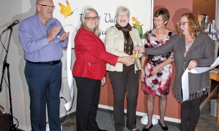
Chief Clarence Louie of the Osoyoos Indian Band and Osoyoos Mayor Stu Wells signed a boundary exchange agreement at the Spirit Ridge Vineyard Resort and Spa on Oct. 27. The agreement allows for the transfer of 16 hectares previously within Town of Osoyoos boundaries into the band’s reserve. Photo by Laurena Weninger - Click on picture for larger image
OSOYOOS TIMES-November 4, 2009
By Laurena Weninger – Osoyoos Times
The Town of Osoyoos and the Osoyoos Indian Band (OIB) have now officially signed an agreement to exchange some land for new roads, and it’s an agreement that brings the OIB one step closer to changing their boundaries and expanding their reserve.
“(Yes, it will be) a loss of land off our tax rolls,” said Osoyoos Mayor Stu Wells about the three lots that will eventually be considered band land instead of Town land.
He was unwilling to comment about how he feels about that loss, good or bad, except to say, “It was a longstanding injustice that is partially being resolved.”
But leading up to that boundary change, Wells and OIB Chief Clarence Louie – in the presence of Osoyoos town councillors CJ Rhodes, Margaret Chadsey and Michael Ryan, and OIB band councillors Charlotte Stringham and Theresa Gabriel – signed an agreement on Oct. 27 at Spirit Ridge Resort.
It will allow for a boundary adjustment around 45th Street, in East Osoyoos, for the purpose of building new roads.
The agreement will allow for 45th Street, the roadway leading to the band’s Nk’Mip Resort, to be repositioned.
It will move west from its current intersection with Hwy. 3.
The changes will create a safer intersection at the highway, will allow for future expansion and connection of roadways in the area, and help to correct the historical loss of traditional OIB lands, paving the way for the band to add recently purchased property in the area to its reserve, states a media release.
The band recently purchased 16 hectares of private property in the area, within Town boundaries (the Metzler, Kalkat and Ferreira properties), using funds provided by the Haynes Land Claim Agreement made between the OIB and the provincial and federal governments in the late-1990s.
That agreement addressed the loss of OIB land from when Judge J.C. Haynes settled in the area 150 years ago and it provided funds for the purchase of land in the Osoyoos and Oliver areas for addition to the OIB reserve.
The band will complete the transfer of this 16-hectare parcel to its reserve in the near future, said Louie.
“With this (road exchange) agreement we can now proceed with the addition to our reserve, moving forward in the critical process of rectifying the historical loss of our traditional lands,” he said.
Chris Scott, the band’s chief operating officer, said the road exchange, and all the accompanying conditions, are pre-requisite to an official assimilation of the lands into the Osoyoos Indian Reserve.
The band will have six months to work out the details as required in the contract, then they will start building the new roads and closing the old portions, completely at the band’s expense.
Scott said he doesn’t know for sure when construction will start, but the roads will ideally be built before next year’s tourist season, perhaps in the spring.
Wells said this project will do good things for OIB members and the citizens of Osoyoos.
“It illustrates the co-operative spirit between the Town and the band as we develop our adjoining properties and promote the economic development of our region,” he said.
He said in addition to having new roads built at no expense to the Town, the exchange will also help Osoyoos get a little bit closer to the goals laid out in the East Osoyoos Transportation Plan.
It will give the Town access for the future extension of Cedar Lane and potential future roadways connecting 45th Street and Cottonwood Drive, which follows through on recommendations of the Town’s earlier Kneeshaw Engineering Report on that area.
At a special open Osoyoos council meeting on Oct. 26, Wells pointed out that this exchange is the result of multiple years of collaboration between the Town and the band council and he considers it an historic event.
Currently, the parcels of land owned by the band are in the Agricultural Land Reserve (ALR).
However, after the transfer of lands to the Osoyoos Indian Reserve, the ALR restrictions will no longer apply.
The repositioning of 45th Street will require the subdivision of the property adjacent to Hwy. 3.
On the east side of the new road, the band plans to build a service station, but there are no plans, as of yet, for the land parcel on the west side of the proposed new road, said Scott.
[email protected]


