By Don Urquhart, Times Chronicle
While many are pondering the seeming lack of winter weather in the South Okanagan with mild temperatures and no snow in the valley bottom, the question on many minds is what this means for the snowpack, crucial for determining drought conditions.
By early January, nearly half of the annual BC mountain snowpack has typically accumulated.
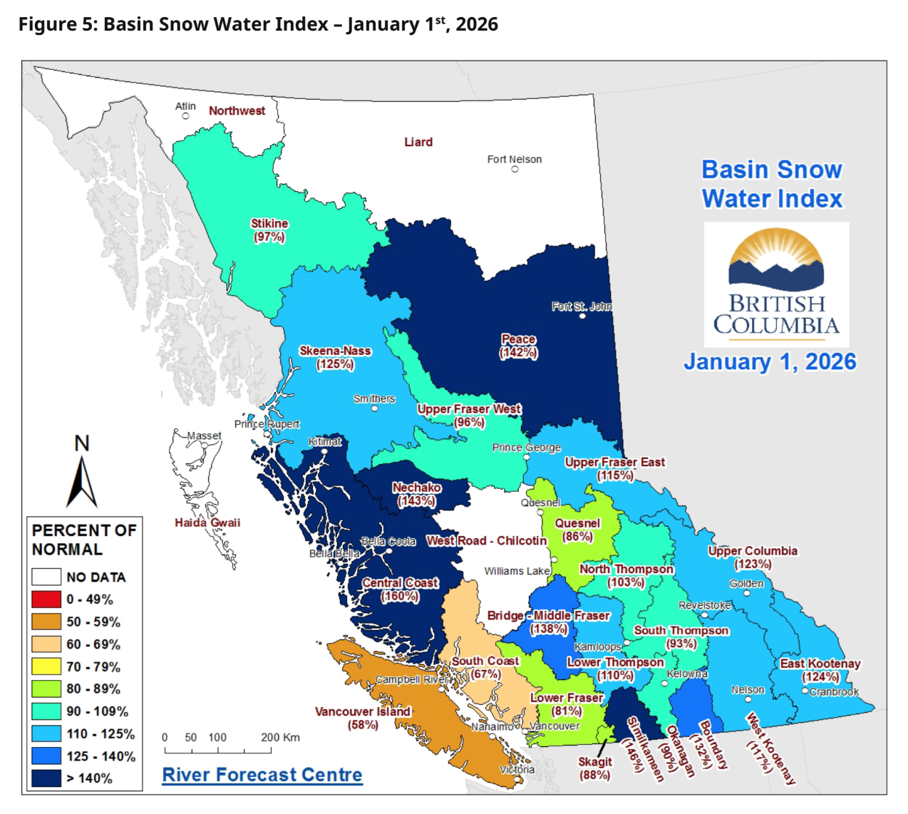
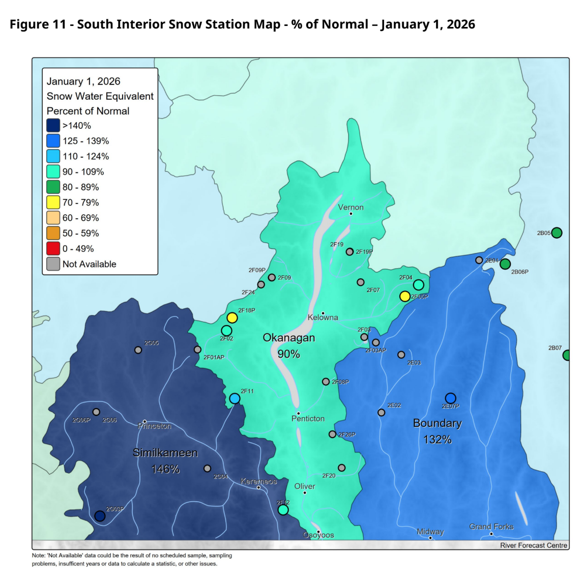
The good news is that BC’s mountain snowpack is currently above normal for early January, averaging 107 per cent across the province, according to the Snow Survey and Water Supply Bulletin released by the River Forecast Centre during the first week of January.
This is a marked increase from last year’s provincial average of 87 per cent at the same time.
However, the report carries an explicit warning: regions registering normal to well above normal snow levels face an increased hazard for spring snowmelt-related flooding, particularly if La Niña weather conditions persist into the spring.
River Forecast Centre graphic
“While the provincial snowpack averaging 107 per cent of normal is a positive sign for water resources, the well-above-normal levels in certain regions raise a red flag,” said a River Forecast Centre official.
“We are closely monitoring the situation as these conditions, coupled with the potential for La Niña to linger, increase the hazard for spring snowmelt-related flooding.”
Snowpack throughout the province ranges from 58 per cent (Vancouver Island) to 160 per cent (Central Coast) of normal across regions. Other areas with below normal snowpack include the South Coast (61 per cent) and Lower Fraser (81 per cent).
The River Forecast Centre cautions that with three or more months remaining in the snow accumulation season, the snowpack can change significantly depending on upcoming weather patterns.
Snowpack development
Snowpack development got off to a solid start across the province with early-season snowfall in October and through mid-November, snow accumulation tracked close to seasonal expectations before a period of dry, stable weather in late-November slowed further development, the report read.
In December, several atmospheric river events impacted BC during the first half of the month, which further built the snowpack except for the South Coast, Lower Fraser and Vancouver Island, where warmer temperatures limited its growth.
The River Forecast Centre noted that the first week of January has seen multiple moderate storm systems move through the province, and mountain snowpack has continued to accumulate at a seasonal rate.
La Niña conditions
The Centre noted that current La Niña conditions are forecast by the Climate Prediction Center (CPC) at the U.S. National Weather Service/NOAA will likely transition to El Niño-Southern Oscillation (ENSO)-neutral conditions in January-March 2026.
La Niña is the cool phase of the ENSO, and historically, La Niña is linked to cooler temperatures for BC and wetter weather for the South Coast and Vancouver Island during the winter months, according to the River Forecast Centre.
When winter La Niña conditions exist in BC, the April 1 snowpack is often above normal, particularly for the South Coast and southern Interior, it said. “La Niña conditions that persist into the spring can lead to late-season snow accumulation and delayed snowmelt, which increases the hazard for freshet flooding.
River Forecast Centre graphic
The River Forecast Centre said it continues to monitor snowpack conditions and will provide an updated seasonal flood hazard forecast scheduled for release around Feb. 10.
