It’s nearly impossible to imagine the force of a river changing its direction in any capacity, but the state of our current climate has made way for these strange instances.
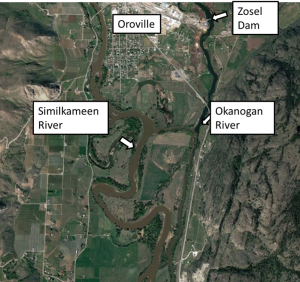
In mid-November when the atmospheric river caused heavy rainfall, the rapid rise in the Similkameen River water levels in turn also caused the Okanogan River to reverse direction.
The BC River Forecast Centre and National Weather Service issued a flood warning for the Similkameen River on Nov. 15 as the river discharge (or the volume of flow through the river channel) peaked at the Nighthawk gauge.
The discharge peaked at 762 cubic meters per second on Nov. 16, the previous historical maximum for November at this specific spot was 420 cubic meters per second on Nov. 30, 1996. The highest recorded was during May 2018 at 883 cubic meters per second.
While the Similkameen River was at a high flow, the Osoyoos Lake on the other hand, had low lake levels and minimal inflow from the Okanagan River. The combination of these two situations created a reversal flow from the Okanogan River that went downstream of Osoyoos Lake.
“In the late evening on Nov. 15, the flow of the Okanogan River at Oroville, Washington reversed direction. At approximately 2:00 p.m. PST on Nov. 16, the river level downstream of Zosel Dam crested the dam’s spillway and began flowing up the channel towards Osoyoos Lake,” according to the International Osoyoos Lake Board of Control report.
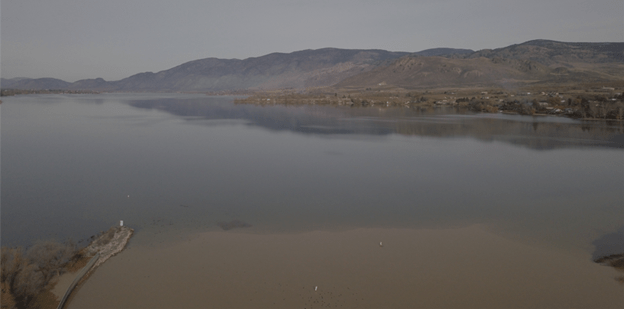
Shown in this aerial photo is the muddy water from the Similkameen River that flowed upstream into the Okanogan River, and contrasts with clear water in Osoyoos Lake. Photo by Mary Davisson.
The aerial photography of the event shows that muddy Similkameen water reached Osoyoos Lake by 11:15 a.m. on Nov. 17 and also shows the upstream flow of the Similkameen River.

