
People prepare to evacuate homes along Highway 97 as the Testalinden fire rapidly approached just before 10 p.m. (Richard McGuire photo)
For a few days, major wildfires were breaking out in every direction from Osoyoos as parched drought conditions left forests and grasslands tinder dry.
To the north, south, east and west, separate fires raged, stretching firefighting resources, exhausting professionals and volunteers and driving hundreds of residents from their homes.
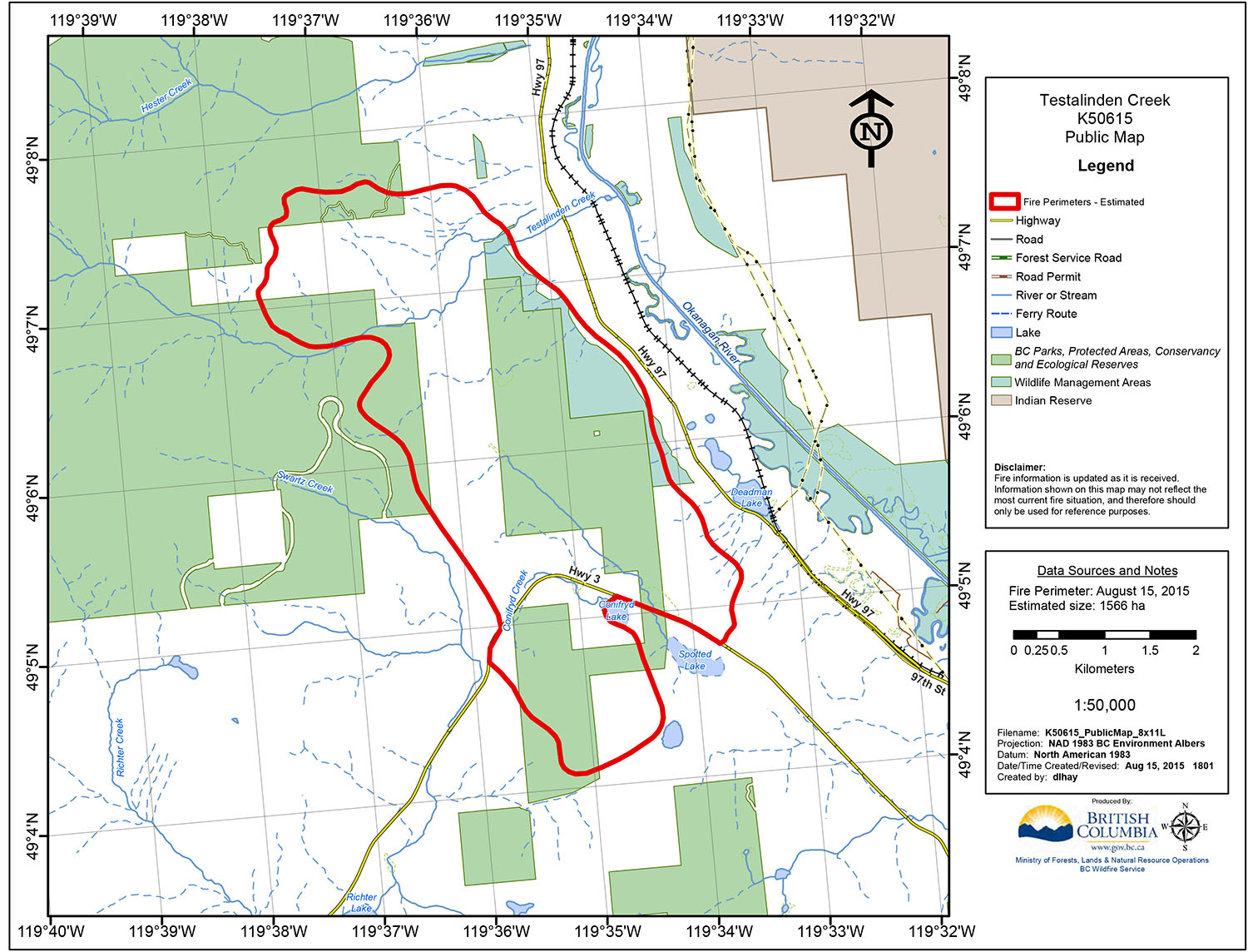
Closest to Osoyoos, the Testalinden Creek fire erupted Friday afternoon on Mount Kobau, burning its way down the slopes almost to Highway 97 over a stretch extending roughly from Road 22 to Road 11.
The fire also swept down the other side of Mount Kobau, jumping Highway 3 between Spotted Lake and Richter Pass, burning its way into Kilpoola Estates just west of Osoyoos.
At least one home was lost there, but officials have not yet released full details.
An evacuation order affecting about 100 homes was only downgraded to an evacuation alert Monday afternoon, but residents at 125 homes were still warned to be ready to leave at a moment’s notice.
The wildfires started breaking out last Thursday, when the largest and most destructive fire started near Rock Creek – apparently with a tossed cigarette – and other fires broke out on Sidley Mountain to the east of Osoyoos and throughout Washington State just to the south.
For several hours Friday and early Saturday, Highway 3 was closed in both directions from Osoyoos with the Testalinden Creek fire closing the road to Keremeos and the Sidley Mountain and Rock Creek fires closing the highway to traffic between Osoyoos and Midway.
Travellers were faced with notices on the Drive BC website advising that there were no local detours available.
The only options for eastbound travellers were to drive all the way to Vernon and contend with long waits at overworked ferries along Highway 6, or travel south of the border, where some roads were closed by fires.
The Rock Creek fire gained the most national media coverage as it swept through a campground with almost no warning, forcing people to flee on foot, many leaving trailers behind.
As of Monday, the fire west of Rock Creek was estimated at 3,750 hectares – 37.5 square miles and was reported as being “zero contained” as of Tuesday morning.
The majority of the fire’s growth occurred Thursday, but the thick smoke reduced visibility making accurate mapping impossible.
That fire had damaged or destroyed about 30 homes and 15 additional structures, according to the Regional District of Kootenay Boundary (RDKB).
Also on Thursday, several fires broke out in Washington State, one when a plane crashed near the Oroville-Chesaw road, killing two people.
A fire by Nine Mile Road, fanned by southerly winds, swept across the border into Canada later Thursday, which initiated the Sidley Mountain fire.
That fire forced evacuation orders or alerts for residents on Anarchist Mountain at Nine Mile Place, Raven Hill Road and Raven Hill Place.
By Friday, an evacuation order for Nine Mile Place was downgraded to an alert and by Saturday the fire was 100 per cent contained.
Although structures burned on the U.S. side, no homes were destroyed by this fire on the Canadian side.
Around 5 p.m. Friday, the winds shifted direction, blowing with ferocity from the north-northwest. Trees were blown over, signs toppled and some structures were damaged.
At the same time, fires began spreading at Testalinden Creek and one kilometre north of Oliver at Wilson’s Mountain Road. Though both fires are still under investigation, it is believed that the Testalinden fire was caused by lightning and the Wilson’s Mountain fire may have been human caused.
The Testalinden Creek fire spread over several days to cover an area estimated at 1,600 hectares and the Wilson’s Mountain fire reached 317 hectares. At least one structure was burned in each fire.
The Osoyoos Times observed the Testalinden Creek fire sweep down the mountain shortly after 6 p.m. Friday. At one point, an airborne piece of burning material landed on dry grass and within minutes flames swept over a wide area of the mountain.
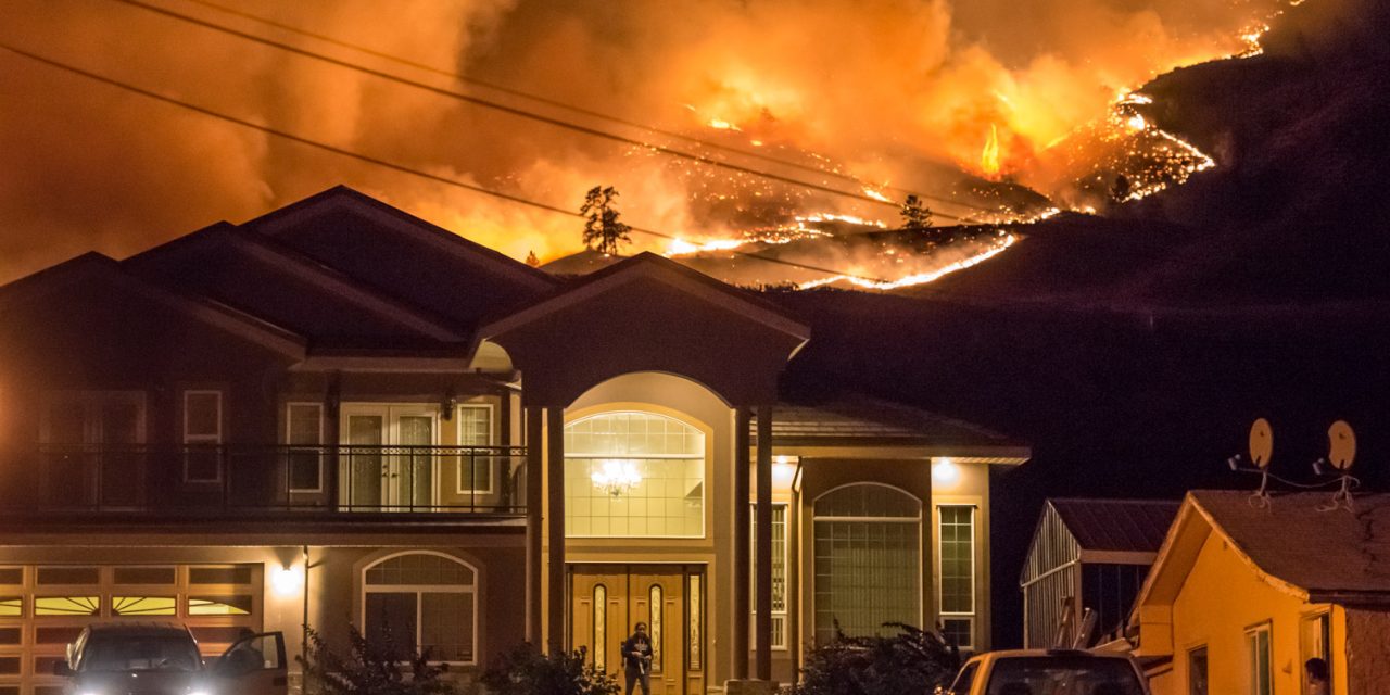
Residents could be seen hosing down rooftops and gathering possessions into vehicles preparing to evacuate.
Responsibility for co-ordinating the emergency and evacuations fell to the Regional District of Okanagan Similkameen (RDOS), which set up a Level 2 Emergency Operation Centre (EOC) on Friday to assist in co-ordinating both fires near Oliver.
They worked closely with B.C. Wildfire Services, who directed the air attack with resources in the Kamloops Fire Centre. Also involved were RCMP and the volunteer fire departments in Oliver, Osoyoos and elsewhere and other community volunteers.
An Emergency Social Services Reception Centre was set up by the RDOS at the Oliver Community Centre. A second reception centre opened Friday night at the Sonora Community Centre in Osoyoos, but closed the following day.
Janette Van Vianen, who co-ordinated the reception centre in Oliver, said about 35 people spent Friday night at group lodging in Oliver and three stayed at the Sonora Community Centre.
Several exhausted firefighters were also given a place to sleep at the Sonora Centre late Friday and early Saturday after battling fires for several hours.
The RDOS issued evacuation orders for 260 homes affected by the Wilson’s Mountain Fire and for 100 homes affected by the Testalinden Creek fire, including those west of Highway 97 and in Kilpoola Estates.
RCMP officers worked through the night notifying residents of the evacuation. Firefighters and structure protection units worked through the night protecting homes and other buildings.
Curious spectators stopped their cars along the roads, many in dangerous locations and blocking traffic, to watch the fires and snap pictures on their phones.
Some entered areas first responders were trying to deal with, interfering with operations.
“It really does hamper our firefighting efforts when people get in the way,” a frustrated Rob Graham, media relations officer with the Oliver Fire Department told a news conference on Saturday, referring to people who gathered on Spartan Street to watch. “If you don’t have to be there, please don’t be there. You’re just putting yourself in danger and putting firefighters in danger. We are busy trying to do the jobs that we need to do.”
As night fell, the side of the mountain above Highway 97 was lit up in a wall of flames rapidly burning towards homes and wineries along the Golden Mile Bench.
On Saturday morning the winds had calmed.
Weary firefighters returned for some much-needed rest and some residents who had evacuated returned to check their properties, even though evacuation orders remained in place.
Charred ground covered the mountains and pockets of smoke and flame still burned.
Helicopters in succession took on water at the ponds around Road 20, dropping bucket after bucket on burning areas around the base of the mountain near Testalinden Creek.
At a 3 p.m. Saturday news conference in Oliver, weary-looking officials and first responders gave a summary of progress.
They also announced that the Wilson’s Mountain fire evacuation order was now downgraded to an alert, although the order for those in the Testalinden Creek fire area remained in effect until Monday.
Oliver Mayor Ron Hovanes was choked with emotion as he thanked the firefighters and other volunteers for their efforts. Also speaking were RDOS Chair and Area A director Mark Pendergraft and Terry Schafer, Area C director, both looking worn out.
“I’ve lived here pretty much my whole life and I don’t think the town or the rural areas have ever been faced with something quite like this before,” Hovanes told reporters and a scattering of local residents. “The community really came together, the volunteers are really precious for the work they do for this community.”
On Sunday, the fires were largely reduced to smouldering ground with minimal open flames, although areas of Mount Kobau were still burning.
Then a setback.
Somebody illegally operating an unmanned aerial vehicle (UAV) or drone over the fire at Testalinden Creek put aircraft at risk.
“Eight helicopters and five fixed-wing aircraft that were supporting ground crews were grounded and significantly impacted fire suppression operations,” B.C. Wildfire Services said in an information bulletin.
It wasn’t until much later in the day Sunday that the air operation was able to resume and by then some new areas were on fire.
The Oliver RCMP is working with the B.C. Wildfire Service to investigate the incident.
Wildfires are considered flight restricted areas and the operation of any aircraft not associated with the suppression activities, including UAVs, in these areas is illegal.
“This aerial activity is dangerous and poses a significant safety risk to personnel, especially when low-flying firefighting aircraft are present,” B.C. Wildfire Services said.
By Monday night, the Testalinden Creek fire was 40 per cent contained and the Wilson’s Mountain fire was 70 per cent contained.
Efforts are expected to continue throughout this week.
RICHARD McGUIRE
Osoyoos Times
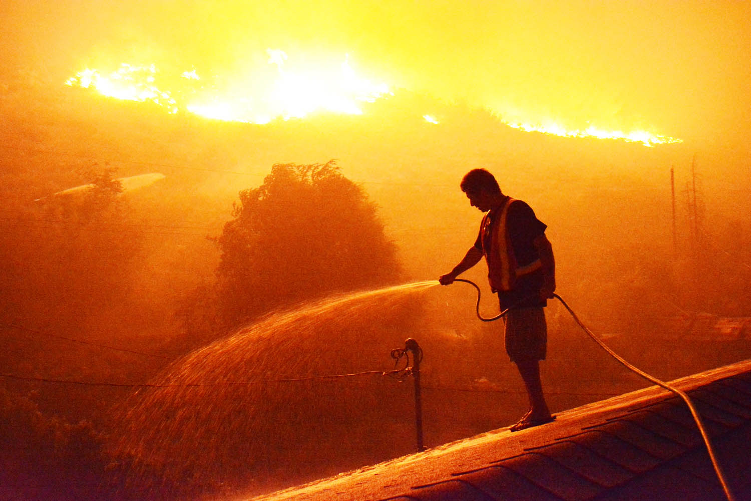
Spartan Street resident J.C. Oliveira from Oliver quickly hoses down his roof as the flames creep towards his backyard last Friday. Oliveira and many other families were evacuated that evening, but were allowed back the following day when the threat subsided. (Lyonel Doherty photo)
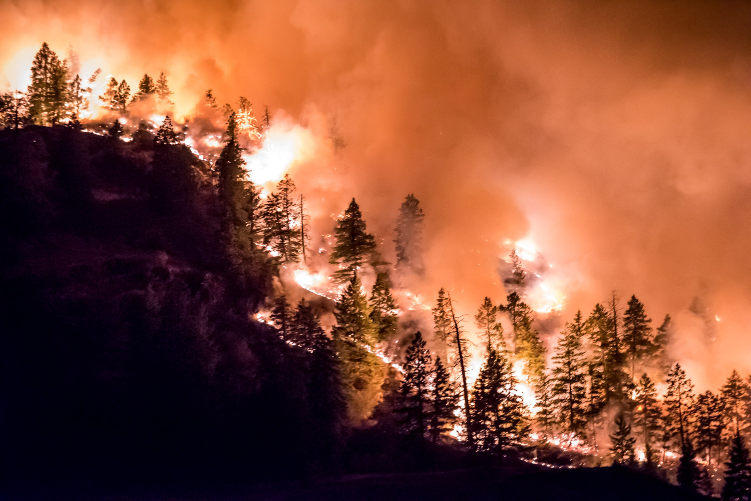
Trees burn as intense flames spread down the base of Mount Kobau just south of Testalinden Creek. This photo was taken at 9:46 p.m. Friday. (Richard McGuire photo)
Many homes were threatened by the advancing Testalinden fire just west of Highway 97. This photo was taken just before 10 p.m. Friday. (Richard McGuire photo)
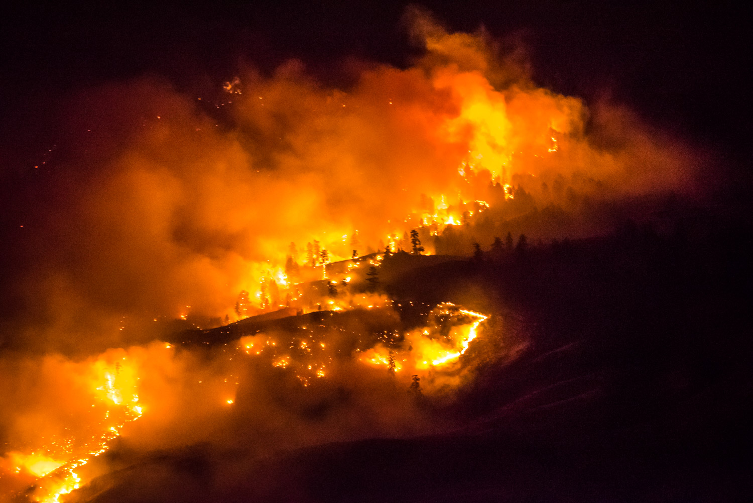
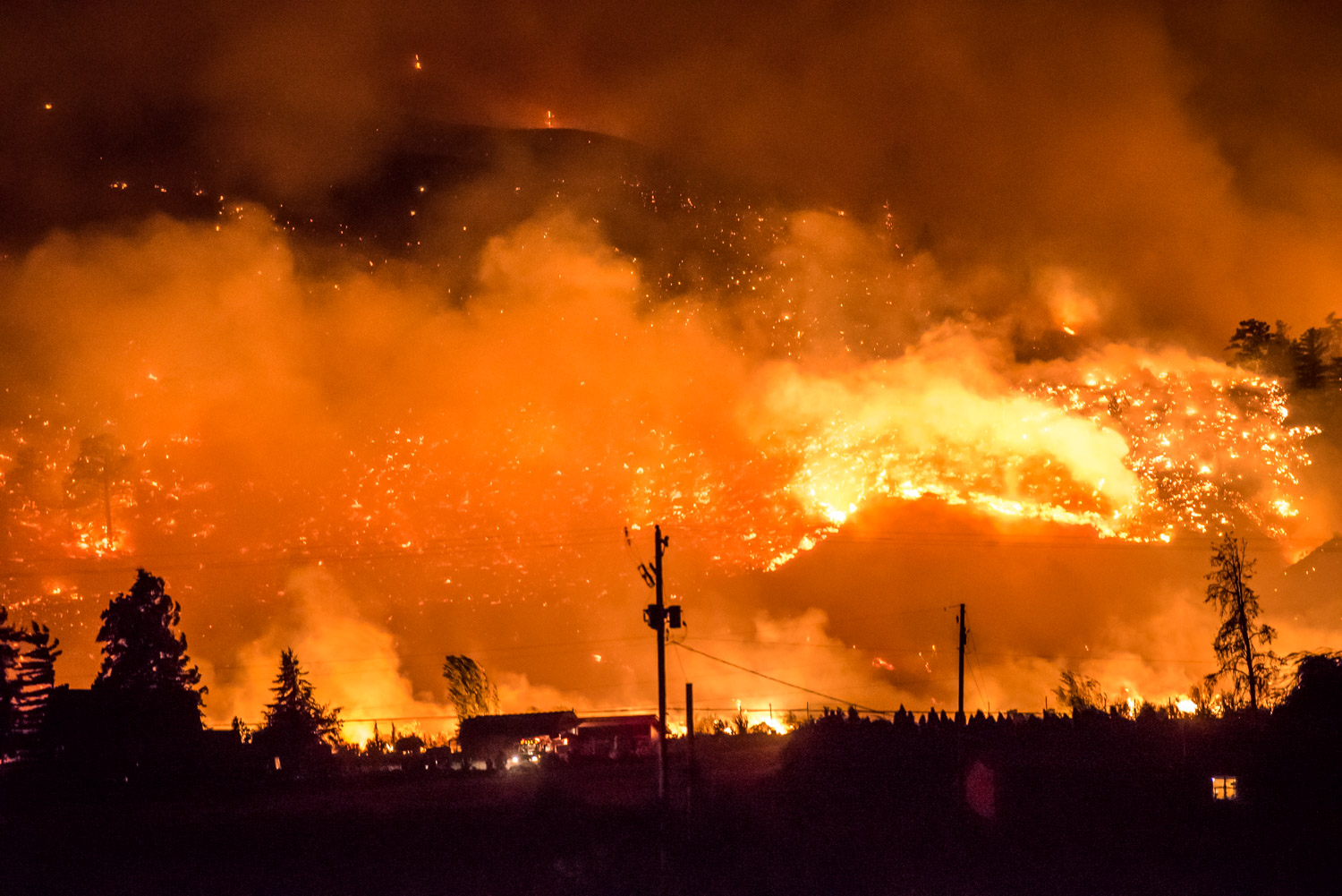
The Testalinden Creek becomes a river of fire down the side of Mount Kobau in the night skies. This photo was taken at 10:06 p.m. Friday. (Richard McGuire photo)
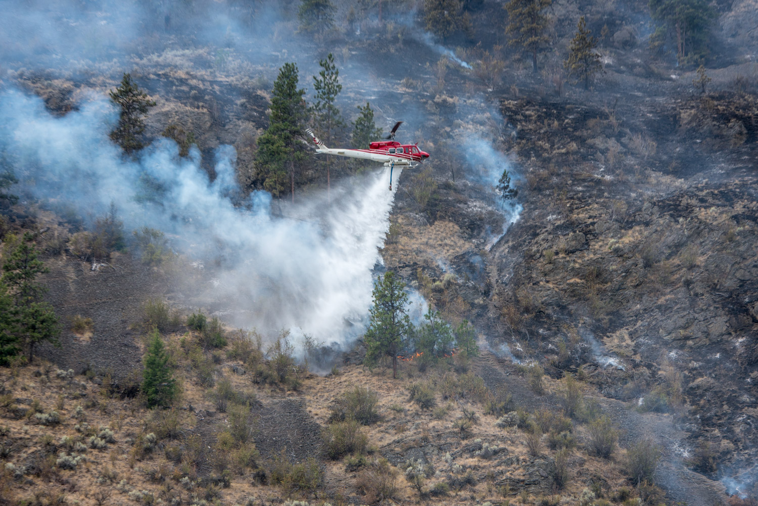
A helicopter drops water from a nearby slough onto the Testalinden Creek fire near Road 20 and Highway 97 just after noon Saturday. (Richard McGuire photo)
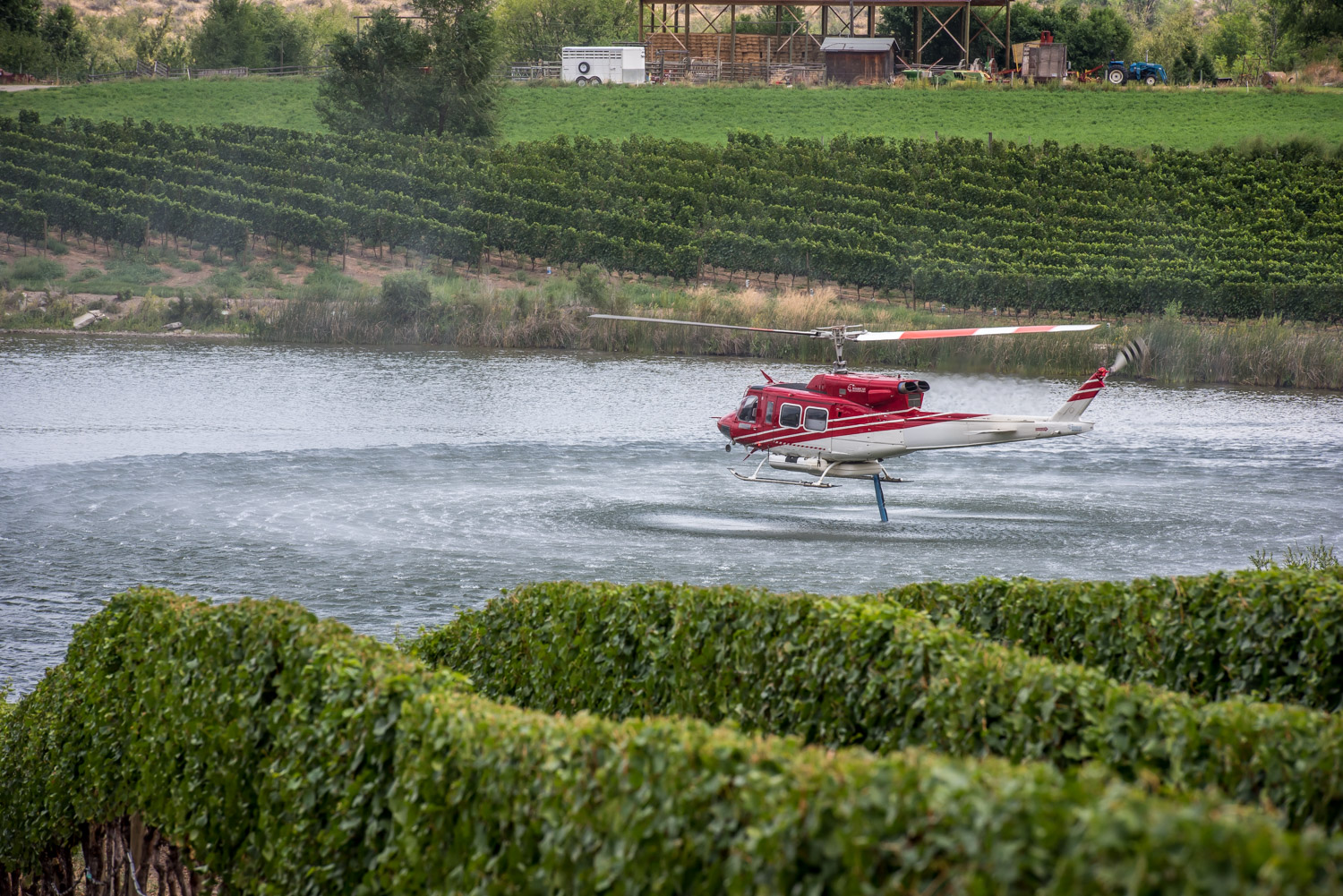
A helicopter picks up water at a nearby slough to drop on the Testalinden Creek fire near Road 20 and Highway 97. This photo was taken at 12:15 p.m. Saturday. (Richard McGuire photo)
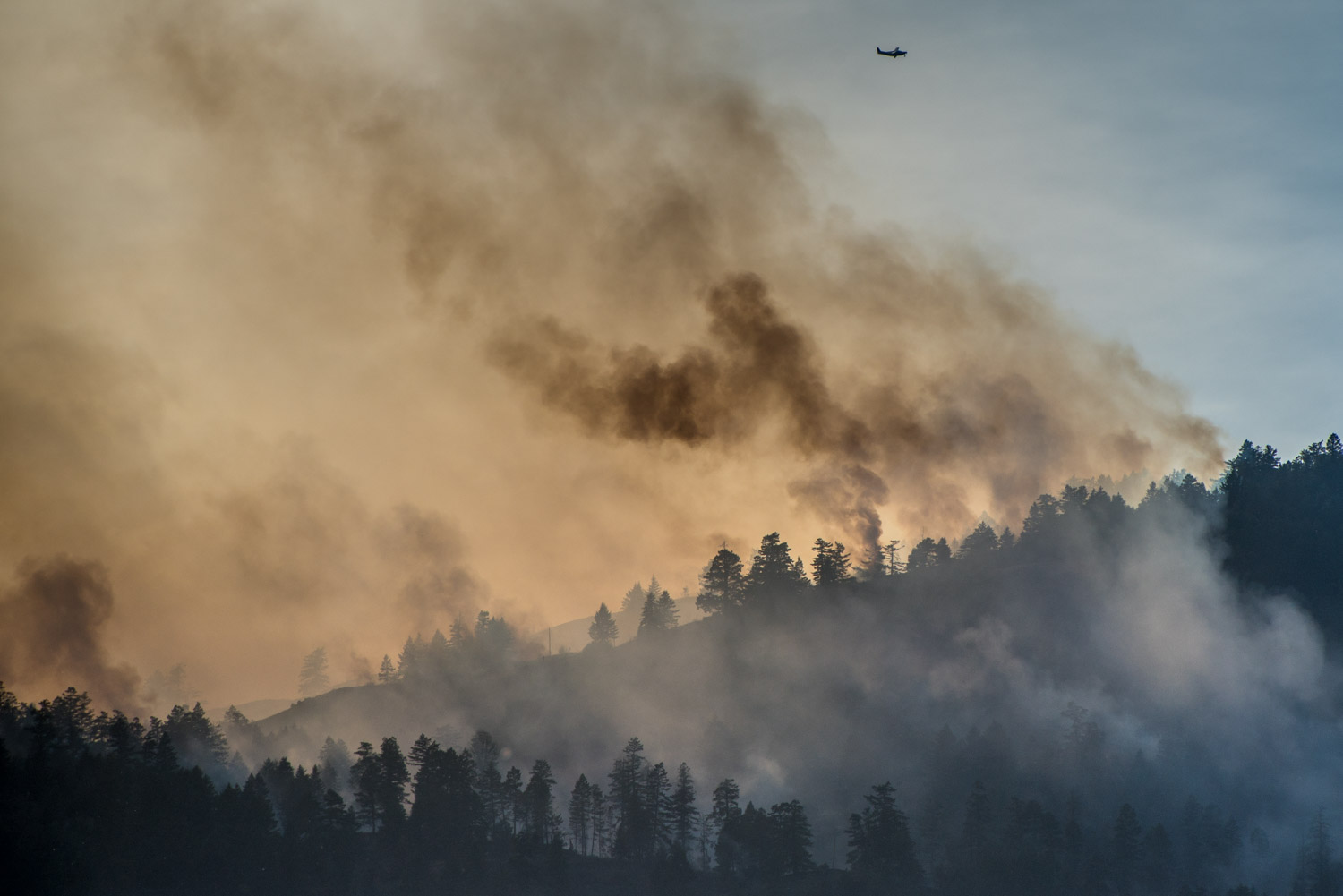
A plane flies over the area above Testalinden Creek as sun strikes the smoke from behind. This photo was taken at 6:15 p.m. Sunday. (Richard McGuire photo)

