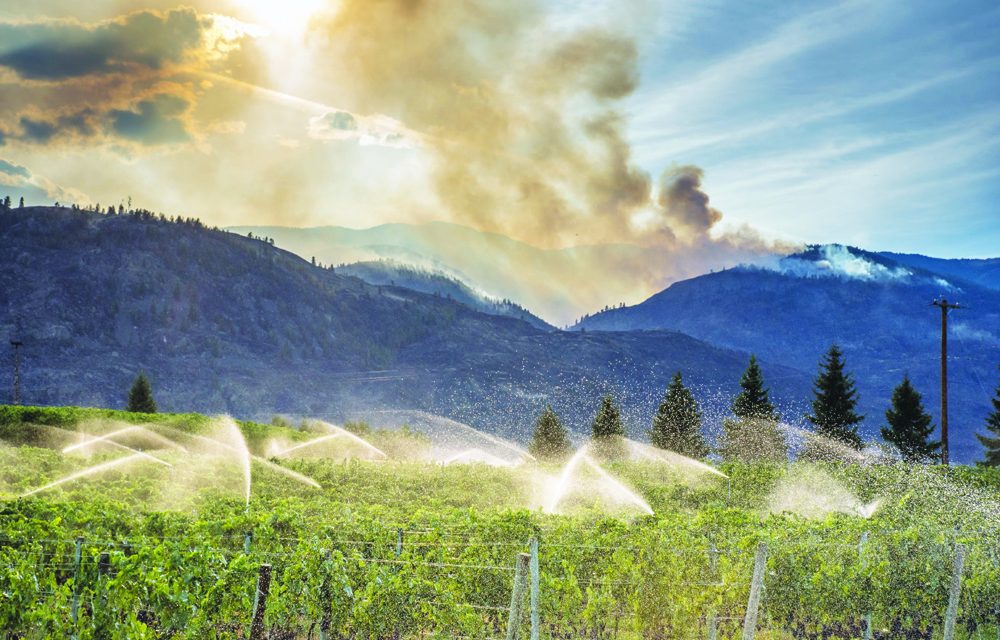

Smoke continues to cause poor air quality, but it is also making it difficult to fight fires, including the one in the Testalinda Creek area. Photo by Richard McGuire
Thick smoke from fires burning in Washington State has reduced visibility in Osoyoos and the South Okanagan for several days, hampering efforts to fight the growing Testalinden Creek fire.
The smoke has led the B.C. Ministry of Environment and Interior Health Authority to issue a smoky skies advisory, cautioning people to avoid strenuous outdoor activity, especially those with heart or lung conditions or diabetes.
With southerly winds picking up over the weekend, the Testalinden Creek wildfire just north of Osoyoos has been growing to the north towards Oliver.
As of Monday night, its size was estimated at 3,170 hectares and the fire was 60 per cent contained.
There were 237 firefighters, 11 helicopters and 21 pieces of heavy equipment deployed to control its spread.
On Saturday, the fire was spilling over onto the steep south slopes of Hester Creek, B.C. Wildfire Services said.
Winds late last week caused the fire to cross containment lines previously established on the north side of Testalinden Creek.
Late Friday, the Regional District of Okanagan- Similkameen (RDOS) expanded the area under evacuation alert northward to include a total of 168 homes or properties affected by the Testalinden Creek wildfire.
That alert remains in effect.
Another fire at Wilson’s Mountain north of Oliver is no longer considered a threat and on Sunday afternoon the RDOS rescinded the evacuation alert for homes affect by that fire.
It is now 100 per cent contained, but as of Monday, 15 firefighters were continuing to work on hotspots within the fire perimeter.
The fires in the B.C. Southern Interior, however, are small compared to massive blazes burning through Washington.
The Okanogan Complex alone had grown to 103,865 hectares Monday, making it the largest fire in the state’s history.
That group of fires is burning on both sides of Omak and has moved north to the edge of Tonasket. It has destroyed a number of homes.
As of Monday, it was only 10 per cent contained.
On Sunday, heavy smoke grounded both fixed-wing aircraft and helicopters for much of the day.
The Kettle Complex, covering more than 22,000 hectares to the east, includes the Stickpin fire just five kilometres south of the Canada-U.S. border near Grand Forks.
That fire, which grew with winds last week, was still only 15 per cent contained as of Monday.
On Sunday, 33 B.C. Wildfire Services firefighters and three officers began work on that fire, where U.S. resources are stretched thin.
Meanwhile, a large fire west of Rock Creek grew last week and has now reached 4,534 hectares.
It is now 75 per cent contained.
Evacuation orders resulting from this fire have now all been downgraded to alerts. Highway 33 was again opened in both directions, but as of Monday, speeds were limited to 60 km/h between Rock Creek and Westbridge.
Most of the thick smoke in the B.C. Southern Interior is from the large wildfires in the U.S., the B.C. Wildfire Service said. A temperature inversion has trapped the smoke in the valley bottoms.
Southerly winds that picked up on Saturday afternoon have spread heavy plumes of smoke, ash and fine particulates northward, resulting in poor air quality.
This is expected to persist until there is a major shift in wind patterns and weather conditions, the Ministry of Environment and Interior Health said.
People should contact their health care provider if they experience difficulty breathing, chest pain or discomfort or a sudden onset of coughing or irritation of airways.
Exposure is particularly a concern for infants, the elderly and those with underlying medical conditions such as diabetes, lung or heart disease.
Last week firefighters continued to fight the Testalinden Creek fire, doing controlled burns on the fire’s northwest flank to starve it of the fuel it needs to spread on Mount Kobau.
Most structures were no longer threatened as of last Thursday, but there are some communication towers on the mountain’s west flank that firefighters were working to protect.
Only the Testalinden Creek fire that broke out Aug. 14 destroyed one residence, Mark Woods, Emergency Operation Centre director with the RDOS, has confirmed.
That home was located on Highway 3 between Spotted Lake and Richter Pass.
Other non-residential buildings were also destroyed or damaged in the fire, he said.
People can donate through the Red Cross for relief efforts for fire victims at B.C. Liquor Stores throughout the province.
By Richard McGuire


