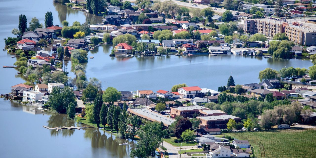

An aerial view of Harbour Key and Solana Key taken on Sunday, May 13 in the afternoon. The lake level was at 916.19 feet above sea level at this time. (Richard McGuire photo)
Nothing shows the altered shoreline during the floods better than an aerial view.
The cost and/or red tape of using a helicopter or drone to get these views was out of the question, so we took a camera and long lens to the Anarchist lookout to take these views of different parts of town affected by flooding.
The long lens compresses the distance. It also can only show the town from one angle. Furthermore, there is almost always haze in the valley, so this had to be digitally corrected.
Nonetheless, these views show the Osoyoos shoreline when Osoyoos Lake was at 916.19 feet above sea level on Sunday afternoon.
(Richard McGuire photos)

An aerial view of Harbour Key and Solana Key taken on Sunday, May 13 in the afternoon. The lake level was at 916.19 feet above sea level at this time. (Richard McGuire photo)

An aerial view of Harbour Key and Solana Key taken on Sunday, May 13 in the afternoon. The lake level was at 916.19 feet above sea level at this time. (Richard McGuire photo)

An aerial view of Harbour Key and Solana Key taken on Sunday, May 13 in the afternoon. The lake level was at 916.19 feet above sea level at this time. (Richard McGuire photo)

An aerial view of Hotel Row taken on Sunday, May 13 in the afternoon. The lake level was at 916.19 feet above sea level at this time. (Richard McGuire photo)

An aerial view of Gyro Park and White Sands taken on Sunday, May 13 in the afternoon. The lake level was at 916.19 feet above sea level at this time. (Richard McGuire photo)

An aerial view showing the Watermark Beach Resort, with Hotel Row in the foreground, taken on Sunday, May 13 in the afternoon. The lake level was at 916.19 feet above sea level at this time. (Richard McGuire photo)

An aerial view showing Hotel Row in the foreground, and Watermark Beach Resort across the water, taken on Sunday, May 13 in the afternoon. The lake level was at 916.19 feet above sea level at this time. (Richard McGuire photo)

An aerial view showing the shoreline between Legion Beach (left) and Kingfisher Drive (right) taken on Sunday, May 13 in the afternoon. The lake level was at 916.19 feet above sea level at this time. (Richard McGuire photo)

An aerial view showing the shoreline between Legion Beach (left) and Kingfisher Drive (right) taken on Sunday, May 13 in the afternoon. The lake level was at 916.19 feet above sea level at this time. (Richard McGuire photo)

An aerial view showing the Watermark Beach Resort taken on Sunday, May 13 in the afternoon. The lake level was at 916.19 feet above sea level at this time. (Richard McGuire photo)

An aerial view showing Haynes Point, with Walnut Beach Resort in the foreground, taken on Sunday, May 13 in the afternoon. The lake level was at 916.19 feet above sea level at this time. (Richard McGuire photo)

An aerial view showing Haynes Point taken on Sunday, May 13 in the afternoon. The lake level was at 916.19 feet above sea level at this time. (Richard McGuire photo)

An aerial view showing Haynes Point, with Walnut Beach Resort in the foreground, taken on Sunday, May 13 in the afternoon. The lake level was at 916.19 feet above sea level at this time. (Richard McGuire photo)


How many feet is it normally above sea level. The 916 makes it seem that it is 900 plus feet above. I would like to know.
Thanks
The level throughout the year varies both according to internationally agreed target levels and weather conditions that are beyond human control. The normal target at this time of year is around 912 feet above sea level. That means Saturday’s 916.45 feet was roughly four and a half feet higher than normal.