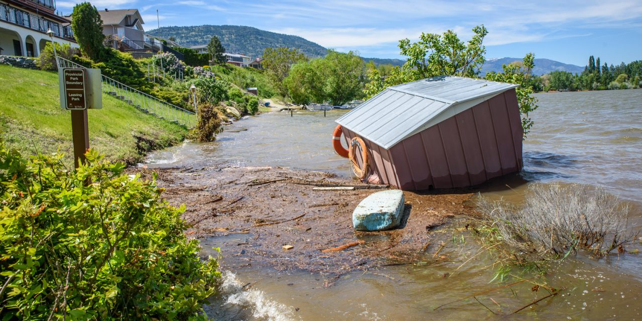

This shed was bobbing in the water beside the submerged trail that connects Oleander Drive with Haynes Point. (Richard McGuire photo)
We posted a series of photos on Friday taken in some of the worst hit flood spots around Osoyoos.
Some readers pointed us to other locations we weren’t able to get to on on Thursday and Friday.
These included the Desert Sunrise Marina, photographed Friday evening, and Legion Beach, Haynes Point and Willow Beach photographed Saturday afternoon.
Osoyoos Lake level was at 916.38 feet when the Saturday photos were taken and 916.40 when the Friday photos were taken.
Osoyoos Lake peaked at 916.45 feet at 11:30 a.m. Saturday, but it has declined from there to around 916.15 by midnight Sunday.
While the lake is moving in the right direction, residents should beware that it could rise again. The Similkameen River, which has an important impact on the speed water can flow out of Osoyoos Lake, has begun rising again after a major drop from since Thursday night. This is likely due to warm temperatures melting snow at higher elevations.
See also:
- Series of photos posted Friday, May 11;
- Video tour of floods on Friday and Saturday, May 11 and 12;
- Mini documentary about local flooding on Thursday, May 11 and origins of the flood in the mountains above the Similkameen River and water coming down the Okanagan River.
(Richard McGuire photos)

The town Desert Sunrise Marina and boat launch were closed due to high water. (Richard McGuire photo)

The town Desert Sunrise Marina and boat launch were closed due to high water. (Richard McGuire photo)

The town Desert Sunrise Marina and boat launch were closed due to high water. (Richard McGuire photo)

Karly Lidstone and Logan Mawer from Kelowna enjoy a Saturday afternoon at what’s left of Legion Beach. Many local beaches had no sand above water. At the time this photo was taken, Osoyoos Lake was at 916.38 feet above sea level. (Richard McGuire photo)

This house on Kingfisher Drive next to Legion Beach was alone on that street in being issued an evacuation order. This photo makes it clear why. (Richard McGuire photo)

Safari Beach Resort had the pumps running and lots of sandbags Saturday afternoon. (Richard McGuire photo)

The host RV at Haynes Point Provincial Park (swiws) is above water and mobile, but the electrical hookup is getting close to lake level. (Richard McGuire photo)

This walking trail through a wetland at Haynes Point is a favourite with birders. It’s impassable now, so the busy birds had the place to themselves. (Richard McGuire photo)

With waters high and a strong north wind, waves lashed up on the roadway to the camping area at Haynes Point. The lake is depositing an enormous amount of forest debris on the shore. The lake was at 916.36 feet above sea level when this photo was taken. (Richard McGuire photo)

With waters high and a strong north wind, waves lashed up on the roadway to the camping area at Haynes Point. The lake is depositing an enormous amount of forest debris on the shore. The lake was at 916.36 feet above sea level when this photo was taken. (Richard McGuire photo)

With waters high and a strong north wind, waves lashed up on the roadway to the camping area at Haynes Point. The lake is depositing an enormous amount of forest debris on the shore. The lake was at 916.36 feet above sea level when this photo was taken. (Richard McGuire photo)

Along with forest debris, old docks and other objects are also washing ashore in the winds. (Richard McGuire photo)

Haynes Point campground was closed along with the rest of the park, but the majority of sites like this one were still above water — though only barely. (Richard McGuire photo)

At the end of the loop in the Haynes Point campground, much of the land, including the roadway, was submerged. About four or five campsites (some were doubles) were flooded in this area. (Richard McGuire photo)

Campsite 18 is normally across the road from the lake, but on Saturday it was part of the lake. (Richard McGuire photo)

Campsite 18 is normally across the road from the lake, but on Saturday it was part of the lake. (Richard McGuire photo)

The path to the sandbar at the end of Haynes Point was closed off and under water. The drowning hazard sign refers to the undertow, but it could apply to walking the path. (Richard McGuire photo)

Campsites and the roadway are flooded near the tip of Haynes Point. (Richard McGuire photo)

Campsites and the roadway are flooded near the tip of Haynes Point. (Richard McGuire photo)

Campsites and the roadway are flooded near the tip of Haynes Point. (Richard McGuire photo)

A barricade indicates that both the park and boat launch are closed at Haynes Point (swiws) Provincial Park. (Richard McGuire photo)

Willow Beach at the north end of Osoyoos Lake is inundated. It was ordered evacuated Thursday evening. You would need a watercraft to get in. (Richard McGuire photo)

Willow Beach at the north end of Osoyoos Lake is inundated. It was ordered evacuated Thursday evening. You would need a watercraft to get in. (Richard McGuire photo)

Willow Beach at the north end of Osoyoos Lake is inundated. It was ordered evacuated Thursday evening. You would need a watercraft to get in. (Richard McGuire photo)