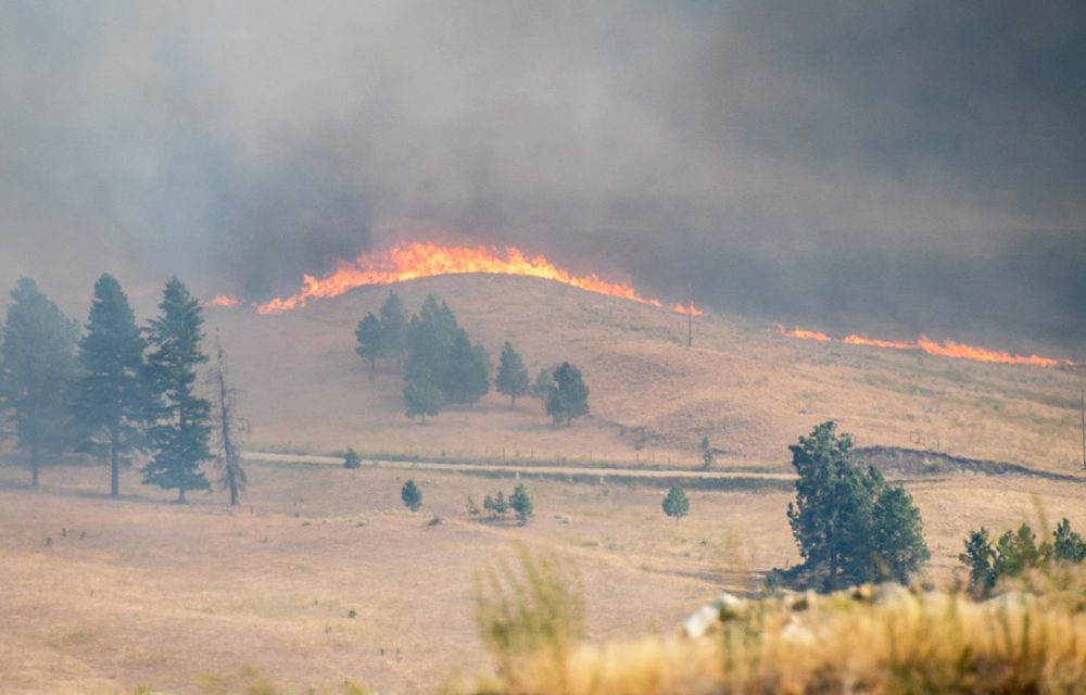

A fire from Washington State has burned its way into Canada (south of Anarchist Mountain) . The regional district has issued an evacuation order for residents of Nine Mile Place. Photo by Richard McGuire
The Regional District of Okanagan-Similkameen has issued an evacuation order for residents of Nine Mile Place on Anarchist Mountain due to a threat of wildfire.
In addition, residents of Raven Hill Road and Raven Hill Place are on evacuation alert for the same fire threat.
A wildfire burning east of Oroville, Washington entered Canada and threatened homes located in the Nine Mile Creek area.
Anarchist Mountain Fire Department personnel responded along with the B.C. Wildfire Service to action the fire.
The Regional District has activated its Emergency Operation Center to support the event.
Wildfires are raging on both sides of the border to the east of Osoyoos.
A fire just west of Rock Creek has closed Highway 3 in both directions.
A separate fire was burning its way into Canada from Washington State on the south of Anarchist Mountain, sending thick clouds of smoke over the mountain. Around 4:30 p.m. Thursday, theOsoyoos Times observed trees candling and large areas of grassland in flames around the border with strong gusts of wind from the south pushing the flames towards Canada.
Helicopters and planes were seen attacking the blaze as it advanced.
Meanwhile, the Omak-Okanogan County Chronicle is reporting that multiple fires were caused along the Oroville-Chesaw road after a plane crashed this morning, killing one person. That road was reported to be closed due to the wildfires. Some area residents were receiving evacuation notices.
The Kamloops Fire Centre was unable to provide details about the fire south of Anarchist when contacted shortly before 5 p.m. because efforts to combat the blaze on the B.C. side were just getting underway.
The B.C. Wildfire Service lists the fire west of Rock Creek as human caused, saying it was discovered on Thursday. The fire was reported at 750 hectares in size. A number of evacuation orders have been issued. There are several smaller fires in the area, including one that forced the evacuation of Kettle Valley campground.
The main Rock Creek fire was upgraded Thursday evening to a “fire of note” as it continued to grow. As of 7:54 p.m., Thursday, there were 32 firefighters, six helicopters, three pieces of heavy equipment and two airtankers were fighting the fire and other resources were en route to the fire. The fire is listed as an interface fire meaning that structures are threatened.
The Regional District of Kootenay Boundary (RDKB) is co-ordinating evacuation orders. Information can be found here.
The RDKB says the fire started at approximately 1:00 p.m. northwest of Rock Creek. The fire spread quickly and in the immediate area, Hulme Creek Road was evacuated.The fire spread quickly north forcing people in the Kettle River Provincial Park to evacuate on foot and the evacuees were tactically evacuated by incident command.
Residents on Christion Valley Road to Fiva Creek were evacuated. Evacuees are directed north, up the Christian Valley Road to Lumby.
Evacuees from Rock Creek to Westbridge are being directed Willow Park Church in Kelowna on Highway 33. Livestock is being received at Rock Creek Fairground.
Highway 33 north of Rock Creek to McColloch Road is also closed in both directions (89.4 km).
There are no local detours on main roads that bypass the closures on Highways 3 and 33.
Travellers heading between Osoyoos and Castlegar may be able to take much longer routes via Highway 6 east from Vernon or on Highway 20 from Tonasket, Washington, then Highway 395 to Christina Lake. Travellers should check for advisories affecting those routes. It is unknown when Highway 3 will reopen, but information can be found at www.drivebc.ca . Information on Washington State highways may be found here.
The Washington State route is several hours shorter, but a passport is required. The Christina Lake Cascade/Laurier border crossing is only open from 8 a.m. to midnight.
The fire danger rating is currently listed as high around Osoyoos and extreme around Rock Creek.
This story will be updated as new information becomes available.
By Richard McGuire

