

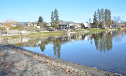
The Zosel Dam in Oroville, WA helps to maintain the level of Osoyoos Lake, but it becomes ineffective when water in the Similkameen River is high and backs up the Okanogan River. Water flow in the Similkameen peaked over the weekend, but has since come down. (Richard McGuire file photo)
A couple months ago, the possibility of floods this spring looked very unlikely, but extended rains, accumulated snowpack and now rapid melting has changed that outlook.
Flooding hasn’t yet occurred around Osoyoos Lake, but depending on weather in the coming week, that could change.
On Monday, the level of Osoyoos Lake was just under 913 feet above sea level and water had risen by about a foot since Friday.
High water levels in the Central Okanagan could have an impact downriver as water is released into the Okanagan River and if it becomes impossible to release more water at the Zosel Dam in Oroville, WA.
Shaun Reimer, who oversees the release of water from Okanagan Lake at the dam in Penticton, warns that the impact of high water levels on that lake will be felt for many weeks to come.
“We are going to have very sustained high flows for the foreseeable future and well into the summer,” said Reimer, section head – Public Safety and Protection for Okanagan Shuswap District with the Ministry of Forests, Lands and Natural Resource Operations (FLNRO).
“It isn’t just a matter of the next week,” Reimer said. “All of this stuff that you see coming down is filling up Okanagan Lake and it’s going to be considered a really high flow year.”
Reimer pointed out that because of the size of Okanagan Lake, it takes a long time to release its water.
If the lake is about 30 centimetres above target or more, it would take about 20 days to bring it down to target if there were no new inflows into the lake – something that never happens.
When inflows into the lake are considered, this means there will be high flows down the Okanagan River to Osoyoos Lake well into the summer.
Reimer said he has a balancing act to manage outflows from Okanagan Lake so that the channel around Oliver doesn’t flood because of other tributaries entering the river.
During storms last week, he had to “back off” or reduce flows through the dam to prevent flooding around the “pinch point” at Oliver.
This week could cause further challenges.
Environment Canada is forecasting temperatures in the mid-20s from Tuesday to Thursday for Osoyoos, contributing to rapid snowpack melt, and they are predicting showers in the second half of the week.
Meanwhile, the B.C. River Forecast Centre on Monday released its May 1 Snow Survey and Water Supply Bulletin showing that snowpack in the Okanagan Basin is almost 50 per cent higher than normal at 147.
The Similkameen Basin was at 146 per cent of normal on May 1. High water flow on the Similkameen River can cause water to back up on the Okanogan River at Oroville, preventing Osoyoos Lake from draining.
“Cool and wet weather through April has led to a significant increase in snowpack conditions across the province, with the biggest increases being observed in south and southeast B.C.,” says the bulletin. “This has been pronounced by a delay in the onset of the snow melt season by about two weeks in most regions of the province.”
At elevations below 1,500 metres, much of the snow has already melted, but significant snow remains at higher elevations. Most regions saw increased melting the first week in May.
The bulletin says elevated seasonal flood risk is present in numerous regions including the Okanagan and Similkameen.
Reimer, from FLNRO, notes that with all the recent rainfall, the ground has become saturated meaning snowmelt isn’t absorbed into the ground, but runs down directly into the waterbodies.
Water flow in the Similkameen River near Nighthawk, WA, has begun decreasing after peaking on Saturday at 15,200 cubic feet per second, according to the U.S. Geological Survey.
As of Monday afternoon, it was down to 11,600 cubic feet per second.
A lower flow in the Similkameen River reduces the likelihood of water backing up into Osoyoos Lake at Oroville. When water from the Similkameen backs up the Okanogan River, the Zosel Dam becomes ineffective at controlling the level of Osoyoos Lake.
Meanwhile, the Regional District of Okanagan-Similkameen (RDOS) reports localized flooding in areas across the district.
In the rural Oliver area, road closures were reported Sunday and sandbags are being distributed in many parts of the RDOS.
Flooding has affected more than 30 homes in the Tulameen, Otter Lake and Otter Creek areas in the west of the district.
The B.C. Government has posted tips for safety near floodwaters and preparing effective sandbags. They can be accessed at this abbreviated link: http://bit.ly/2pVtFP0.
RICHARD McGUIRE
Osoyoos Times


